Argument Mapping
Advertisement
ILogos v.1.5.0
iLogos is a cross-platform tool that allows you to easily construct and share argument maps. Argument mapping tools.Argument maps are diagrams that display the structure of an argument. By combining pictures and words,
Advertisement
Rationale
Rationale is the first high-quality "argument processing" software. Use Rationale to create "argument maps", diagrams of reasoning and argument. Rationale will help students learn the fundamentals of good reasoning, critical thinking, and argumentative
Macrobject DObject O/R Mapping Suite
Macrobject DObject suite is an O/R Mapping (Object-Relation Mapping) component package to be used in Borland Delphi. DObject O/R Mapping suite supports a variety of databases and transparent to users and needn't to alter code when switching to different
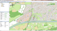
Eye4Software GPS Mapping Studio v.4.1
GPS Mapping Software for Windows, Loading topographic maps, Realtime navigation, GPS position tracking, Map import and export, Coordinate conversion and more
Graham Process Mapping Professional v.7.10.0517
With the Graham Process Mapping Software and methodology, detailed process maps are easy to draw, easy to edit and easy to read. Eight basic process mapping symbols cover all aspects of work at the element level.
ESRI Defense Mapping v.10.0
Esri Defense Mapping (formerly PLTS for ArcGIS-Defense Solution) allows defense industry users to produce and maintain high-quality topographic databases and cartographic products.
TrackLogs Digital Mapping v.3.15.1
TrackLogs Digital Mapping include genuine Ordnance Survey digital data and are visually identical to the paper Explorer and Landranger maps. The maps show footpaths, bridleways and contours, just like the paper ones.
Eye4Software GPS Mapping Software v.3.0.10.927
Eye4Software GPS Mapping is a professional GPS mapping software tool that can be used in numerous applications. Use the software to load, view and edit your maps, display your position realtime and record all your movements.
IP-Country mapping Database v.1 2
Where are your Internet visitors coming from? IP Address Country mapping Database can help you identify visitor's geographical location of an IP address. The IP Address to Country Code Database can be used for: 1>Real Time Geo-Locating (
Tone Mapping Plug-In v.2.0.2
Plug-in of Photoshop CS2/CS3/CS4/CS5. The Tone Mapping Plug-In for Photoshop is a plug-in. It offers only Tone Mapping and works within Photoshop CS2, CS3, CS4 or CS5.
OrbitGIS Microdrone Airborne Mapping v.1.0
The Microdrone Airborne Mapping extension to Orbit GIS provides the tools required for automated flight and high precision mapping. It contains a Waypoint Generator, a Microdrone in-flight tracker, and a captation tool.